Tuesday, April 17, 2012

Reflection #1


For my comparison location, I have chosen to look at Eugene, OR. Eugene and San Pedro Sula fluctuate pretty widely from each other in temperature, precipitation, and in the air masses effecting both of these locations. Interestingly enough, one geographical similarity between the locations is that both cities sit in a river valley. Even though both locations sit in a valley, they have different elevations; San Pedro Sula sits at 102 feet above sea level, while Eugene is at 419 feet above sea level.


Honduras Physical Map

By Maps.com -- http://www.maps.com/ref_map.aspx?cid=694,727,744,836&pid=12074 --  North latitude: 15.4503 /West latitude:  -87.9295


Map of Honduras

http://www.travellingclub.org/maps/honduras/map-of-honduras.html


San Pedro Sula geographical/terrain map 

 http://maps.live-translator.net/HN/San-Pedro-Sula/geographicalmap.ph


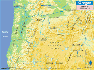
Oregon Physical Map

By Maps.com

http://www.maps.com/ref_map.aspx?cid=680,692,784,1233&pid=12680 --
North latitude: 44.057663 /West longitude: -123.110345


Oregon Physical Geography Map

By Maps.com -- http://www.maps.com/ref_map.aspx?cid=680,692,784,1233&pid=12680


Eugene geographical/terrain map -- 

http://maps.live-translator.net/US/Eugene/geographicalmap.php


Eugene, Oregon and San Pedro Sula, Honduras are effected by different air masses, both locations have precipitation through out the year however Eugene has a higher annual average precipitation. The rainier months in Eugene are the dryer months in San Pedro Sula. 


Eugene Climate Graph - Oregon Climate Chart 

-- http://www.usclimatedata.com/climate.php?location=USOR0118


Average minimum and maximum temperature over the year

The monthly mean minimum and maximum daily temperature. Show temperatures in Fahrenheit » -- http://www.weather-and-climate.com/average-monthly-Rainfall-Temperature-Sunshine,San-Pedro-Sula,Honduras


Average monthly precipitation over the year (rainfall, snow) This is the mean monthly precipitation, including rain, snow, hail etc. -- http://www.weather-and-climate.com/average-monthly-Rainfall-Temperature-Sunshine,San-Pedro-Sula,Honduras


Oregon is effected by mP, cP and, on rarer occasions, mT air masses which makes the climate for the majority of the year wet and cold. San Pedro Sula is effected by mT and E air masses and stays hot and humid almost consistently through out the year.


Some weather that is common in Eugene due to west to east weather rising over a large orographic barrier is: fog, strong winds.  


Oregon Coastal Barrier


Willamette Valley fog -- 

http://en.wikipedia.org/wiki/File:Willamette_Valley_fog.JPG


 In San Pedro Sula, even though it is closer to the equator where the Coriolis effect is at its weakest, this location still experiences hurricanes due to the North and South fluctuations of the ITCZ.


Hurricane Mitch Exclusive Photos


San Pedro Sula in Honduras, Central America
On Thursday October 29th, 1998

http://www.hurricanemitch.com/mitch7.html#.T4205o5gNcw 


Thursday, April 12, 2012

Weather and climate in San Pedro Sula, Honduras.

Honduras is a country located in Central America that borders Nicaragua (south east), Guatemala, and El Salvador (west). Honduras also borders the Caribbean Ocean in the north and the Pacific Ocean on the smaller  southern coast. 

Map of Honduras SidewalkMystic.com   


The weather station is located at the MHLM, or the La Mesa International Airport, San Pedro Sula, Honduras.


Picture of San Pedro Sula/La Mesa International Airport Information: "Latitude: 15° 27 1" N (deg min sec), 15.4503° (decimal), 1527.02N (LORAN) Longitude: 87° 55 46" W (deg min sec), -87.9295° (decimal), 08755.77W (LORAN) Elevation: 31 metres (102 feet) -- validated against 27 metres (90 feet) from Google WMO Id: 78708 Location: La Mesa San Pedro Sula , Honduras"( http://weather.gladstonefamily.net/site/MHLM). 


San Pedro Sula is in the northwestern part of the country sitting in the Ulua River Valley; it is 37 miles or 60 km inland. San Pedro is at Lat:15.50 Lon: -88.03 average elevation: 84m


Satellite image of San Pedro Sula, Honduras Tageo.com GPS city index & satellite map To better visualize the valley San Pedro Sula is sitting in, the following URL will take you to a San Pedro Sula terrain map: http://maps.live-translator.net/HN/San-Pedro-Sula/geographicalmap.php


The following graphs discern the yearly average precipitation and the yearly average temperatures for San Pedro Sula. The temperatures and precipitation have similar monthly patterns.


Average Yearly Precipitation for San Pedro Sula, Honduras Copyright © 2012 El Dorado Weather, Inc. | Site Designed & Maintained By: El Dorado Weather http://www.eldoradocountyweather.com/climate/central%20america/Honduras/San%20Pedro%20Sula.htm.World Temperature Map © 2007 Climate-Charts.com World Temperature Map © 2007 Climate-Charts.comWorld Temperature Map © 2007 Climate-Charts.com


GREENH factor-1.00 Albedo-0.306—15.0°C/58.9°F
GREENH factor-1.00 Albedo-0.206—24.8°C/76.7°F; hotter with higher precipitation
GREENH factor-1.00 Albedo-0.406—4.0°C/39.1°F; lower precipitation dryer and cooler.
GREENH factor-1.10 Albedo-0.306—17.7°C/63.9°F; higher annual temperatures and precipitation.
GREENH factor-0.90 Albedo-0.306—12.1°C/53.8°F; lower annual temperatures and precipitation.


Average Global Temperatures:


Air Masses Map This is a file from the Wikimedia Commons. http://en.wikipedia.org/wiki/File:Air_masses_.svg BR=H/LE for San Pedro Sula, Honduras is a maritime locale; ~0.40.