Tuesday, April 17, 2012

Reflection #1


For my comparison location, I have chosen to look at Eugene, OR. Eugene and San Pedro Sula fluctuate pretty widely from each other in temperature, precipitation, and in the air masses effecting both of these locations. Interestingly enough, one geographical similarity between the locations is that both cities sit in a river valley. Even though both locations sit in a valley, they have different elevations; San Pedro Sula sits at 102 feet above sea level, while Eugene is at 419 feet above sea level.


Honduras Physical Map

By Maps.com -- http://www.maps.com/ref_map.aspx?cid=694,727,744,836&pid=12074 --  North latitude: 15.4503 /West latitude:  -87.9295


Map of Honduras

http://www.travellingclub.org/maps/honduras/map-of-honduras.html


San Pedro Sula geographical/terrain map 

 http://maps.live-translator.net/HN/San-Pedro-Sula/geographicalmap.ph


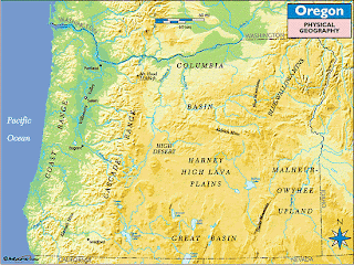
Oregon Physical Map

By Maps.com

http://www.maps.com/ref_map.aspx?cid=680,692,784,1233&pid=12680 --
North latitude: 44.057663 /West longitude: -123.110345


Oregon Physical Geography Map

By Maps.com -- http://www.maps.com/ref_map.aspx?cid=680,692,784,1233&pid=12680


Eugene geographical/terrain map -- 

http://maps.live-translator.net/US/Eugene/geographicalmap.php


Eugene, Oregon and San Pedro Sula, Honduras are effected by different air masses, both locations have precipitation through out the year however Eugene has a higher annual average precipitation. The rainier months in Eugene are the dryer months in San Pedro Sula. 


Eugene Climate Graph - Oregon Climate Chart 

-- http://www.usclimatedata.com/climate.php?location=USOR0118


Average minimum and maximum temperature over the year

The monthly mean minimum and maximum daily temperature. Show temperatures in Fahrenheit » -- http://www.weather-and-climate.com/average-monthly-Rainfall-Temperature-Sunshine,San-Pedro-Sula,Honduras


Average monthly precipitation over the year (rainfall, snow) This is the mean monthly precipitation, including rain, snow, hail etc. -- http://www.weather-and-climate.com/average-monthly-Rainfall-Temperature-Sunshine,San-Pedro-Sula,Honduras


Oregon is effected by mP, cP and, on rarer occasions, mT air masses which makes the climate for the majority of the year wet and cold. San Pedro Sula is effected by mT and E air masses and stays hot and humid almost consistently through out the year.


Some weather that is common in Eugene due to west to east weather rising over a large orographic barrier is: fog, strong winds.  


Oregon Coastal Barrier


Willamette Valley fog -- 

http://en.wikipedia.org/wiki/File:Willamette_Valley_fog.JPG


 In San Pedro Sula, even though it is closer to the equator where the Coriolis effect is at its weakest, this location still experiences hurricanes due to the North and South fluctuations of the ITCZ.


Hurricane Mitch Exclusive Photos


San Pedro Sula in Honduras, Central America
On Thursday October 29th, 1998

http://www.hurricanemitch.com/mitch7.html#.T4205o5gNcw 


No comments:

Post a Comment